


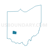
PRECINCT FAIRBORN 210, Greene County, Ohio
About
Outline

Summary
| Unique Area Identifier | 646777 |
| Name | PRECINCT FAIRBORN 210 |
| County | Greene County |
| State | Ohio |
| Area (square miles) | 0.16 |
| Land Area (square miles) | 0.16 |
| Water Area (square miles) | 0.00 |
| % of Land Area | 100.00 |
| % of Water Area | 0.00 |
| Latitude of the Internal Point | 39.81091100 |
| Longtitude of the Internal Point | -84.01835910 |
Maps


Graphs
Select a template below for downloading or customizing gragh for PRECINCT FAIRBORN 210, Greene County, Ohio


Neighbors
Neighoring Voting District (by Name) Neighboring Voting District on the Map
- PRECINCT FAIRBORN 208, Greene County, OH
- PRECINCT FAIRBORN 209, Greene County, OH
- PRECINCT FAIRBORN 211, Greene County, OH
- PRECINCT FAIRBORN 212, Greene County, OH
- PRECINCT FAIRBORN 224, Greene County, OH